
WILD SAG HARBOR
Welcome to Wild Sag Harbor!
This tour will introduce you to the many surprising and beautiful shores, parks and preserves in our immediate vicinity. Many of the stops on this tour are further-flung than in our other tours, but you'll find them very doable, often by bicycle, and they offer stunning beaches, forests and grasslands, and wildlife.
In all seasons, the environs of Sag Harbor offer opportunities for walks, biking, cross-country skiing, boating, fishing, and swimming that you and your family are sure to enjoy.
.
Sittin' on the Dock of the Bay
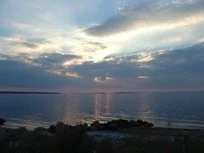
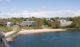
We’d be remiss if we didn’t point out the beauty of the coves and bays around Sag Harbor itself which are, significantly, part of the Peconic Estuary. Windmill Beach adjacent to Long Wharf, Havens Beach, Marine Park, Upper Cove, and Long Beach, just 2 miles outside the village all provide different varieties of interaction. Besides the community-wide festivities at HarborFest and HarborFrost that take place at the water's edge, people enjoy boating, waterskiing, swimming, paddle boarding, fishing and picnicking.
Our waterfront is the heart of our Village, and we are very concerned about its preservation and health for the recreational and aesthetic enjoyment of all who live and visit here. We value and commend organizations, as well as the Village-appointed Harbor Committee, who work to raise awareness of its importance. Our history is inextricably bound to our being the only Village on waterfront on the East End.
Did you know: The Peconic Estuary Program is a partnership of concerned community members; local, state, and federal governments; environmental groups, businesses and academic institutions, all working to protect and restore Long Island's Peconic Bays. Our estuary, which lies between the North and South Forks of Long Island, has been deemed as a U.S. Environmental Protection Agency Estuary of National Significance.

Marine Park
The Waterfront from the Bridge
Havens Beach †

Whaleboat Races at Windmill Beach‡

The Waterfront from the Bridge
.
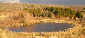
Mashashimuet Park and Otter Pond
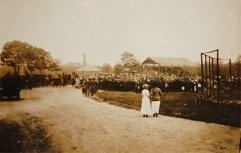
In 1874, what is now Mashashimuet Park was the Hamptons Driving Park and Fair, and by 1879 a half-mile oval track was built for carriage team races, trotting, and walking races. You can see the festive atmosphere in the old photo shown here, and it must have been quite a draw. The park’s popularity showed in its new name: Sag Harbor, Hampton and Shelter Island Park and Fair Grounds. It even expanded with an exhibition building built for judging produce, poultry, flowers and baked goods, although that building was destroyed by one of Sag Harbor’s many fires in 1890.
In 1893 the Great Bicycle Tournament attracted over 1,000 spectators, but sadly, by 1900 the park grounds began to deteriorate.
In 1908 Mrs. Russell Sage, philanthropist, bought and decided to refit the Sag Harbor Park and Fair Grounds with “scientifically designed” equipment and amenities, hoping to convert it from its vulgar amusements to those more uplifting. There were, for instance, 114 plots for children’s gardens, and weekly band concerts. In 1910 she also purchased the lands surrounding Otter Pond to add to the Park property, and moved 13 houses off the land to give to needy families.
She also allowed William Wallace Tooker, self-trained ethnologist and “Algonkinist”, to rename the park in 1908 with the Algonquin name Mashashimuet, meaning “Place of the Great Springs”, the name it still enjoys today.
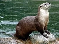
The park today hosts tennis courts, playgrounds, baseball games, and also serves as an entrance to the Long Pond Greenbelt, a beautiful stretch of land described elsewhere on this tour. Mallards, egrets and cormorants can be found at Otter Pond, and the Pond itself is part of the extensive pond system of the Long Pond Greenbelt.
Did you know: Long Island once hosted beavers, bobcats, wolves and bears. Otters were also common but were hunted to near local extinction by the early 1800s. Currently, the Long Island River Otter Project is hoping to re-establish the otter as a familiar mammal here, which has been successfully done in areas of the Midwest. If you spot an otter, as sometimes happens, please email Mike Bottini at mike@peconic.org
The Park in Its Previous Incarnation as Fairground and Track

View of Otter Pond #

Baseball in the Park §
River Otter ‖

Mashashimuet Park Today #
The Long Pond GreenbelT
Friends of the Long Pond Greenbelt is dedicated to the preservation, stewardship, and public appreciation of the unique expanse of coastal plain ponds, freshwater swamps, wetlands, and woodlands in the Town of Southampton known as the Long Pond Greenbelt, which stretches from Ligonee Creek in Sag Harbor to Sagg Pond in Sagaponack. (– Friends of the Long Pond Greenbelt Mission Statement)
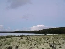
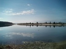
The Long Pond Greenbelt is comprised of many different significant areas, including Long Pond, Crooked Pond, Round Pond, Little Poxabogue Pond, Slade Pond, Lily Pond, Vineyard Field Pond, and Fore-and-Aft Pond. Otter Pond, also part of the Greenbelt, is in Sag Harbor Village itself, and some of the Greenbelt's ponds have been attractive to endangered tiger salamanders. Its actual size, 1,100 acres, actually extends to the Atlantic Shore in Sagaponack, and is widely recognized as one of the most ecologically significant areas of New York State.
The State of New York, Suffolk County, Southampton Town and The Nature Conservancy have all played a part in preserving the Long Pond Greenbelt. Friends of the Long Pond Greenbelt, came into being after the bulk of the lands in the Greenbelt were brought into conservation ownership created by Southampton Town, Suffolk County and the Conservancy. The Conservancy began by pledging to focus on land protection around Crooked Pond, and the Sagg Swamp preserve was added in the 1990’s in a cooperative purchase with the Town of Southampton. Suffolk County focused on the southern end of the LPG around Poxabogue Pond. The County bought lots between Long Pond and Round Pond at the north end of the Greenbelt. The Town of Southampton focused on key western parcels, which built linkages between other protected lands, and picked up the old Vineyard Fields parcel in Bridgehampton. The Town acquired land the former Val Schaffner house, now used as a Nature Center and adjacent to Round Pond, securing the northeast shore of that water body from further development. Individuals like Nancy Boyd Willey, whose longer story can be found in our Women of Sag Harbor tour, were important contributors. The state of New York committed bond act money to a small purchase on the south-west corner of Long Pond for public access. Upwards of $50 million has gone into protecting the landscapes and pondscapes of the area. This is a stunning example of stewardship and cooperation that deserves to be emulated elsewhere.
There are exciting projects afoot, notably in Vineyard Field, which sits immediately behind the South Fork Natural History Museum, which is being restored as an “old field” grassland habitat (once common on Long Island and an important ecological condition for the continuation of many species). You can enjoy many walks, including walks to search for tiger salamanders, moonlight hikes, and self-guided walks, that are often co-sponsored by the Friends of the Greenbelt and the Museum.
Maps of walks can be purchased from the Greenbelt's website. Visitors may enter at Vineyard Field behind the South Fork Natural History Museum, or even from as far north as the south end of Mashashimuet Park in Sag Harbor proper.
Did you know: Tiger salamanders are almost entirely terrestrial as adults, and usually only return to the water to breed, but they are good swimmers. They are extremely loyal to their birthplaces, and will travel long distances to reach them. However, a single tiger salamander has only a 50% chance of breeding more than once in its lifetime! so protection of their habitat is of obvious concern.
Be sure to bring water, bug repellent, and sunscreen on any walk you take in our area!

Long Pond (Photo: Jean Held), Crooked Pond +

Tiger Salamander (Photo: Glenn Bartolotti)
Field Pond +

Nancy Boyd Willey *

Crooked Pond +
The Long Pond Greenbelt
Friends of the Long Pond Greenbelt is dedicated to the preservation, stewardship, and public appreciation of the unique expanse of coastal plain ponds, freshwater swamps, wetlands, and woodlands in the Town of Southampton known as the Long Pond Greenbelt, which stretches from Ligonee Creek in Sag Harbor to Sagg Pond in Sagaponack. (– Friends of the Long Pond Greenbelt Mission Statement)
The Long Pond Greenbelt is comprised of many different significant areas, including Long Pond, Crooked Pond, Round Pond, Little Poxabogue Pond, Slade Pond, Lily Pond, Vineyard Field Pond, and Fore-and-Aft Pond. Otter Pond, also part of the Greenbelt, is in Sag Harbor Village itself, and some of the Greenbelt's ponds have been attractive to endangered tiger salamanders. Its actual size, 1,100 acres, actually extends to the Atlantic Shore in Sagaponack, and is widely recognized as one of the most ecologically significant areas of New York State.
The State of New York, Suffolk County, Southampton Town and The Nature Conservancy have all played a part in preserving the Long Pond Greenbelt. Friends of the Long Pond Greenbelt, came into being after the bulk of the lands in the Greenbelt were brought into conservation ownership created by Southampton Town, Suffolk County and the Conservancy. The Conservancy began by pledging to focus on land protection around Crooked Pond, and the Sagg Swamp preserve was added in the 1990’s in a cooperative purchase with the Town of Southampton. Suffolk County focused on the southern end of the LPG around Poxabogue Pond. The County bought lots between Long Pond and Round Pond at the north end of the Greenbelt. The Town of Southampton focused on key western parcels, which built linkages between other protected lands, and picked up the old Vineyard Fields parcel in Bridgehampton. The Town acquired land the former Val Schaffner house, now used as a Nature Center and adjacent to Round Pond, securing the northeast shore of that water body from further development. Individuals like Nancy Boyd Willey, whose longer story can be found in our Women of Sag Harbor tour, were important contributors. The state of New York committed bond act money to a small purchase on the south-west corner of Long Pond for public access. Upwards of $50 million has gone into protecting the landscapes and pondscapes of the area. This is a stunning example of stewardship and cooperation that deserves to be emulated elsewhere.
There are exciting projects afoot, notably in Vineyard Field, which sits immediately behind the South Fork Natural History Museum, which is being restored as an “old field” grassland habitat (once common on Long Island and an important ecological condition for the continuation of many species). You can enjoy many walks, including walks to search for tiger salamanders, moonlight hikes, and self-guided walks, that are often co-sponsored by the Friends of the Greenbelt and the Museum.
Maps of walks can be purchased from the Greenbelt's website. Visitors may enter at Vineyard Field behind the South Fork Natural History Museum, or even from as far north as the south end of Mashashimuet Park in Sag Harbor proper.
Did you know: Tiger salamanders are almost entirely terrestrial as adults, and usually only return to the water to breed, but they are good swimmers. They are extremely loyal to their birthplaces, and will travel long distances to reach them. However, a single tiger salamander has only a 50% chance of breeding more than once in its lifetime! so protection of their habitat is of obvious concern.
Be sure to bring water, bug repellent, and sunscreen on any walk you take in our area!

The Museum

Lower Floor Touch Tank
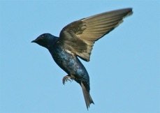
Purple Martin (Photo copyright Dick Daniels, Wikicommons)

Ecosystems Exhibit (Photos courtesy Roger Marvel Architects)
Anna and Daniel Mulvihill Preserve
William Mulvihill (1923-2004), a teacher of history and creative writing, was also the author of Sands of the Kalahari (made into a very successful Hollywood movie). He was a Sag Harbor native and ardent environmentalist. He and his sister, Dolores Mulvihill Zebrowski (1922-2012), herself an dedicated preservationist, established the Anna and Daniel Mulvihill Preserve in memory of their parents, then comprised of 75 acres in Noyac and dedicated as a preserve in 2003. Mulvihill was curmudgeonly about development and wanted land kept as protected from the built environment as possible. He was anguished at the expansion of the East End, and warned of it losing its essential beauty if development continues.
The preservation of the preserve was made possible through a cooperative effort by three environmentally sensitive families – the Mulvihill, Zebrowki, and Schellinger families, who worked with officials from Southampton Town, The Peconic Land Trust and Suffolk County in order to formulate a plan for the preservation of this land. The Mulvihill Preserve was re-dedicated in 2014 with an addition of 11.4 acres, and its trails border magnificent wetlands, including Great Swamp. Its trails are marked by yellow owl blazes, and it may be entered at 820 Brick Kiln Road. Wildlife include sharp-shinned, Cooper’s and red-tailed hawks, red foxes, and white-tailed deer, and it is also a good place to see passerines and ducks.
Did you know: Adult sharp-shinned hawks will pass food to their young in mid-air. They will hover briefly and kick the prey outward just as their fledgling arrives.
Be sure to bring water, bug repellent, and sunscreen on any walk you take in our area!

Trail in the Anna and Daniel Mulvihill Preserve ¶

A Sharp-Shinned Hawk ‖

William Mulvihill in Africa in the 1970s ‖

Trail Across a Brook ¶

Preserve Center ¶
Linda Gronlund Memorial Nature Preserve
Barcelona Neck, as this beautiful preserve had been known, was renamed the Linda Gronlund Memorial Nature Preserve in honor of Sag Harbor native Linda Gronlund, who was aboard Flight 93 when it crashed in Shanksville, PA on September 11, 2001. It's fitting that this park is an example of the preservation work of another great Sag Harbor woman, Nancy Boyd Willey, both cited in our Women of Sag Harbor tour.
The Preserve is a peninsula in Northwest Harbor that has stunning views of the water and huge beds of cinnamon fern nestled between upland forest and lowland swamps, as well as marshes, cliffs, and sandy beaches. It includes Northwest Creek, Little Northwest Creek, and Northwest Harbor.
You will cross the Sag Harbor Golf Club, located within the preserve, when you enter on Barcelona Neck Road just south of Sag Harbor on Route 114. There are marked trails that run along the water and into the woods, comprising about a 4-5 mile hike. Diamond-backed terrapin and Southern leopard frogs live here. Hiking, bird watching, fly fishing, and the trapping and hunting of waterfowl, small and big game, nighttime fox and raccoon are all permitted at the Preserve. This park is also great for cross-country skiing in winter. If you want to follow the Department of Environmental Conservation trails, you must get a DEC Access Permit (631-444-0273). Permits are free but fines for hiking on these trails without one may be as high as $250.
Did you know: Like the cat, the fox has sensitive whiskers and spines on its tongue. It walks on its toes, which accounts for its elegant, cat-like tread. Many foxes have retractable claws that allow them to climb rooftops or trees. Some foxes even sleep in trees—just like cats. Foxes use the earth’s magnetic field and their sensitive hearing to hunt, even in deep snow. Foxes as pets predate dogs, as a grave of a man and his pet fox in Jordan from 16,500 years ago attests.
Be sure to bring water, bug repellent, and sunscreen on any walk you take in our area!

Inlet in the Preserve

Red Fox Near a Bird Feeder

A Perfect Place for Cross-Country Skiing
Twilight at the Preserve
Linda Gronlund Memorial Nature Preserve
North Haven Village Jeanne Vielbig Loop Trail
North Haven Village Jeanne Vielbig Loop Trail
One little-known but delightful walk in our immediate vicinity is a trail that begins just behind the North Haven Village Hall, at 335 Ferry Road, which winds through a small marshy field, forest, along and across Genet Creek and then back again, taking perhaps 45 minutes to complete. This trail sports glorious fall colors, and there is a playground for children at the Hall as well. The one caveat to using the trail is that during deer-hunting season, you may want to call the Hall to find out whether the trail is open (631-725-1378). This is a lovely walk well worth discovering, and was named the Jeanne Vielbig Loop Trail in honor of a past Vice President of the North Haven Trails Association, now disbanded.
Did you know: Eastern Box Turtles can live to be 80-100 years old! They terrestrial and omnivorous, have few offspring per year, are largely extinct in Nassau County due to human encroachment on their habitats. Their decline has been noted in Suffolk County. Please drive carefully, and if you see one crossing the road and stop to help, try to put it on the other side in the direction it was headed.
Be sure to bring water, bug repellent, and sunscreen on any walk you take in our area!

Two Views of Eastern Box Turtles


North Haven Woods in Fall

Snowy Egret (Photo courtesy North Haven Trails Association)

North Haven Woods in Spring
Elizabeth A. Morton National Wildlife Refuge
The Elizabeth A. Morton National Wildlife Refuge, part of the US Fish and Wildlife Service, lies a bit further afield than some listings here on this tour, but is absolutely worth a visit. It’s found at 2595 Noyac Road, and its abundant wildlife includes piping plovers, terns, ospreys, wild turkeys, painted turtles and foxes. Jessup’s Neck, a beach habitat that separates Little Peconic Bay from Noyack Bay, is an important migration corridor for a variety of birds, with bluffs, sandy and rocky beaches, fresh and saltwater marshes and ponds, lagoons, old fields, and oak and cedar forests.
Birds are so accustomed to people walking the Morton trails that they will land on visitors’ hands outstretched with birdseed (sunflower seeds are a particular favorite). This lovely park’s trails are short, taking about 45 minutes, and it would be a good place to bring binoculars to see which wildlife might be visiting Jessup’s Neck. It is also marvelous to visit in the winter, when waterfowl such as long-tailed duck, common goldeneye, and white-winged scoter are temporary residents.
There's also a small freshwater swimming hole called Trout Pond on the way to the refuge, at the corner of Noyac and Ruggs Roads, that has a small but pretty trail around and past its perimeter.
Did you know: Ospreys are found on every continent except Antarctica, and they can close their nostrils when plunging into the water to catch prey.
Be sure to bring water, bug repellent, and sunscreen on any walk you take in our area!

Winter Sunset (Photo: Leslie Fuller)

Fearless Chickadee

Ospreys and Nest (Photo: Matt Edmonds, Wikimedia)

Jessup’s Neck
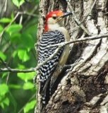
Red-Bellied Woodpecker
Mashomack Preserve
Mashomack Preserve, immediately across and accessible by ferry from Sag Harbor, is run by The Nature Conservancy. It has 12 miles of coastline, and acres of creeks, woodlands and fields. It actually covers a third of Shelter Island, which was originally inhabited by Manhasets, Native Americans that were part of the Algonquin culture. In 1653, Sachem (Chief) Pogatticut of the Manhasets deeded all of Shelter Island to Nathaniel Sylvester, a sugar merchant from Barbados who owned 200 slaves yet established a Quaker refuge on the island. Mashomack (meaning “where they go by water”) was then sold to William Nicoll in 1693, and various parcels were sold to others. The area was due for real estate development, but luckily the Market Crash of 1929 curtailed this plan. Fish and game clubs leased the property for years, and finally The Nature Conservancy was able to purchase the land for preservation in 1979.
When you enter the Preserve, you will have a choice of several trails of different lengths to follow, all of which offer stunning views of the water surrounding Shelter Island, with old growth birch areas, fern gullies, splendid marshes, and a rather extraordinary grassland field (yellow trail). The abundant flora and fauna of the preserve includes 200 species of birds, some rare moth species, including the Luna and Imperial, and in the only natural community of its kind on Long Island, you may find the Pine Swamp Complex, comprised of plants rooted in a floating mat of sphagnum moss. The organic accumulations here can be ten feet thick and date to 3,900 years old. The Swamp is fringed by water willows and swamp azalea, highbush blueberry, white alder, winterberry and mountain holly, as well as two state-protected orchids: the whorled pogonia and the pink lady slipper. Ruby throated hummingbirds, which use the Usnea lichen growing on shrubs and trees here for their nests, can be spotted.
Mashomack Preserve is open 9am to 5pm, March through September, and 9am to 4pm October through February. The preserve is closed Tuesdays, except in July and August when it is open 7 days/week. In January, the preserve is open only on the weekends. A suggested donation of $3.00 per adult and $2.00 per child will help it continue its mission to protect Mashomack for generations to come.
Did you know: Adult Luna Moths do not have a mouth, which is why they only live about a week. Their sole purpose is to mate. They also don’t have noses, but use pheromones to find partners, detecting odor through their antennae from up to 7 miles away. Females produce 100-300 eggs, and lay them on the undersides of leaves. Luna moths are members of the giant silkworm family.
Be sure to bring water, bug repellent, and sunscreen on any walk you take in our area!

Inlet View

Luna and Imperial Moths (Photo: Wikipedia)

Great Field

Fall Colors

Trail at Mashomack
Before You Go (Hiking, of course!)
In addition to these sites, you may want to go further afield by visiting the websites of the Southampton Trails Preservation Society, the East Hampton Trails Preservation Society, and the Long Island Trail Lovers Coalition.All organizations sponsor and offer regular outstanding free guided hikes throughout the year.
Lyme disease, as in many parts of the US, is prevalent here. Be sure to wear an effective bug spray, and/or clothing treated with Permethrin, and check yourself for ticks after hiking. In addition, tucking pants into socks, nerdy as it is, is one of the most effective methods of prevention. Serious as Lyme disease is, fairly simple measures will protect you, and common sense behavior (like staying on trails) will greatly reduce your chance of getting it. Generally, if an attached tick has not become engorged and can be removed head-intact, your chances of infection are low. Please refer to the CDC website for more information.
We also want to give a special salute to two organizations here who help our wildlife survive in our increasingly populated community. These are the Evelyn Alexander Wildlife Rescue Center, located in Hampton Bays, which takes in injured, abandoned and sick wildlife of all kinds. Their mission is: To preserve & protect our region's native wildlife by providing rehabilitation services and education to raise public awareness of the factors that threaten its abundance and diversity. Please call 631-728-9453 if you find an animal in need of their assistance.
The other is the Quogue Wildlife Refuge, a 300 acre non-profit nature preserve that was founded in 1934 and is home to diverse wildlife. Open 365 days a year from sunrise to sunset, there are seven miles of trails to explore diverse habitats including forests and ponds, as well as the ecologically rare Dwarf Pines in the Pine Barrens. The Refuge cares for resident wild animals who are permanently injured and cannot be returned to the wild, which are used as educational ambassadors for the protection of wildlife.
Should you find an injured turtle, please contact Turtle Rescue of Long Island.
And last but not least, did you know: Animals such as antelope resemble deer, but have horns instead of antlers, the difference being that horns are not grown and replaced like antlers are.
Some Additional Reference Material:
Trail Guide to the South Fork – Mike Bottini (available at the South Fork Natural History Museum)
Exploring East End Waters – Mike Bottini (available at the South Fork Natural History Museum)
Exploring the Other Island; a Seasonal Guide to Nature on Long Island – John Turner
Hiking Long Island – Lee McAllister
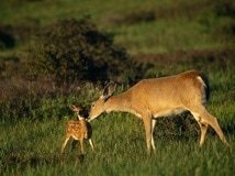
Deer and Fawn ‖

Snowy Egret

Quogue Wildlife Refuge Trail (Photo QWR)

Buck with Felted Antlers

South Fork Trail

Baby Opossum (Photo: Evelyn Alexander Wildlife Rescue Center)
Stand-Off at the L’Hommedieu House
The L’Hommedieu House is where brothers Oliver and Jared Wade Jr. held out for a week with harpoon guns aimed at a mob outside it.
The story is this: While the Civil War raged, it became more and more difficult to attract volunteers to the Army. Men who had families were reluctant to leave them, and of course casualties were staggering. In response, towns offered cash to enlistees. East Hampton, for example, offered $400 to each man who volunteered, plus a whopping $3 per month to his wife and $1 to each child. However, not every town was able to meet its quota, and in 1863 the Federal Government issued a draft. The first draft selection in New York in July 1863 resulted in tremendous riots in the City which spilled over into Long Island. Lisa Donneson’s Guide to Sag Harbor Landmarks describes that in Sag Harbor Oliver Wade, having heard that threats were being made against the African-American residents of Eastville (since African-Americans were blamed for the war by many), found rifles and distributed them among the Eastville residents for their protection. He was then threatened himself, so he holed himself up in the L’Hommedieu House armed with harpoon guns fitted with iron slugs, ready to protect himself. Luckily, no fighting ensued and after a week everything returned to normal. Oliver spent most of his adult life in this house.
George McClellan, Lincoln’s Democratic opponent, vacationed in Sag Harbor and East Hampton in the summer of 1863, and was well-liked, but In spite of the rancor caused by the draft and resentment of the war, in the election of 1864 the normally Democrat-leaning town of East Hampton had elected Lincoln by eight votes.
You’ll notice that this house looks more like a New York brownstone than the other houses of Sag Harbor. Samuel L’Hommedieu built it c. 1840, in anticipation that Sag Harbor, home of the booming whaling industry, would soon be as densely populated as New York City. Samuel L’Hommedieu himself was the grandson of a Huguenot fugitive, Captain Ephraim L’Hommedieu, a Revolutionary War veteran now buried in the Old Burying Ground above the Old Whalers' Church. Samuel operated a ropewalk, a long narrow building where workers walked back & forth twisting hemp into rope for use in ship’s riggings, line and cables. The ropewalk was situated in nearby Peter’s Green, just off Glover Street.

L’Hommedieu House*

Harpoon Gun of 1800s

Grave of Ephraim L’Hommedieu §
The Ponies vs the Philanthropist
In 1874, what is now Mashashimuet Park was the Hamptons Driving Park and Fair, and by 1879 a half-mile oval track was built for carriage team races, trotting, and walking races. You can see the festive atmosphere in the old photo shown here, and it must have been quite a draw. The park’s popularity showed in its new name: Sag Harbor, Hampton and Shelter Island Park and Fair Grounds. It even expanded with an exhibition building built for judging produce, poultry, flowers and baked goods, although that building was destroyed by one of Sag Harbor’s many fires in 1890.
In 1893 the Great Bicycle Tournament attracted over 1,000 spectators, but sadly, by 1900 the park grounds began to deteriorate.
Enter Mrs. Olivia Slocum Sage (1828-1918). Her inherited fortune was from her husband, Russell Sage, who made a killing in the unregulated stock market. Mrs. Russell Sage had great affection for Sag Harbor, the childhood home of her mother, and purchased the Huntting House, now the Sag Harbor Whaling and Historical Museum, after his death in 1906, spending her summers there between 1908 and 1912. Mrs. Sage was an ardent philanthropist and particularly sought to help the many poor immigrants employed at Fahys Watchcase Factory. In 1908 she bought and decided to refit the Sag Harbor Park and Fair Grounds with “scientifically designed” equipment and amenities, hoping to convert it from its vulgar amusements to those more uplifting. There were, for instance, 114 plots for children’s gardens, and weekly band concerts. In 1910 she also purchased the lands surrounding Otter Pond to add to the Park property, and moved 13 houses off the land to give to needy families. Mrs. Sage also underwrote edifying activities like lectures and folk-dancing for the Atheneum Theater (see The Performance That Brought the House Down).
Pierson High School was another project of Mrs. Sage’s, constructed at the same time, and its name commemorated her ancestor Abraham Pierson, first rector of Yale University in 1702. Finally, she was principal benefactor of a new domed building which became the John Jermain Memorial Library, named for a local successful merchant who was her grandfather.
Mrs. Sage’s generosity was not entirely appreciated by the community, and Mrs. Sage abandoned her manse in anger in 1912 after discovering that contractors for Pierson High School had cheated her by using cheap construction materials rather than those she had paid for. There were also reports of vandalism against fixtures in her park. She did allow William Wallace Tooker, self-trained ethnologist and “Algonkinist”, to rename the park in 1908 with the Algonquin name Mashashimuet, meaning “Place of the Great Springs”, the name it still enjoys today.

Mrs. Sage

Whaling Museum‡
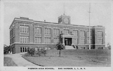
Pierson High*

The Park*

The JJML Library*

The Old Racetrack*